|
|
|||||||||||||||||
| Point ID: 275 | Downloads | Plots | Site Data | Code: 05BG003 |
|
|
|||||||||||||||||
| Download | |
|---|---|
| Site Descriptor Information | Site Time Series Data |
| Link to all available data | |
| View: | Time Series | All |
| Units: | mm |
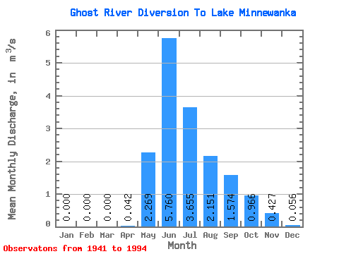
| Statistic | Jan | Feb | Mar | Apr | May | Jun | Jul | Aug | Sep | Oct | Nov | Dec | Annual |
|---|---|---|---|---|---|---|---|---|---|---|---|---|---|
| Mean | 0.00 | 0.00 | 0.00 | 0.04 | 2.27 | 5.76 | 3.66 | 2.15 | 1.57 | 0.97 | 0.43 | 0.06 | 1.41 |
| Standard Deviation | 0.00 | 0.00 | 0.00 | 0.09 | 1.23 | 2.20 | 1.60 | 1.11 | 0.87 | 0.40 | 0.24 | 0.12 | 0.38 |
| Min | 0.00 | 0.00 | 0.00 | 0.00 | 0.46 | 1.24 | 1.28 | 0.55 | 0.65 | 0.00 | 0.00 | 0.00 | 0.69 |
| Max | 0.00 | 0.00 | 0.01 | 0.50 | 6.01 | 11.00 | 7.49 | 5.80 | 4.37 | 2.00 | 1.26 | 0.65 | 2.38 |
| Coefficient of Variation | 7.07 | 2.20 | 0.54 | 0.38 | 0.44 | 0.51 | 0.55 | 0.41 | 0.57 | 2.10 | 0.27 |
 Return to R-Arctic Net Home Page