|
|
|||||||||||||||||
| Point ID: 2747 | Downloads | Plots | Site Data | Code: 09AA014 |
|
|
|||||||||||||||||
| Download | |
|---|---|
| Site Descriptor Information | Site Time Series Data |
| Link to all available data | |
| View: | Time Series | All |
| Units: | mm |
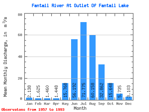
| Statistic | Jan | Feb | Mar | Apr | May | Jun | Jul | Aug | Sep | Oct | Nov | Dec | Annual |
|---|---|---|---|---|---|---|---|---|---|---|---|---|---|
| Mean | 2.14 | 1.62 | 1.46 | 1.45 | 15.77 | 56.19 | 71.78 | 60.16 | 32.86 | 15.65 | 5.74 | 3.10 | 22.22 |
| Standard Deviation | 0.63 | 0.40 | 0.74 | 0.56 | 8.95 | 12.90 | 11.47 | 10.45 | 11.81 | 6.14 | 1.96 | 1.09 | 3.13 |
| Min | 1.07 | 0.93 | 0.70 | 0.67 | 4.49 | 34.60 | 44.90 | 36.00 | 14.40 | 5.06 | 2.39 | 1.56 | 16.10 |
| Max | 3.67 | 2.44 | 5.04 | 2.82 | 41.60 | 81.60 | 91.10 | 83.60 | 58.70 | 33.60 | 12.50 | 7.13 | 28.13 |
| Coefficient of Variation | 0.29 | 0.25 | 0.51 | 0.38 | 0.57 | 0.23 | 0.16 | 0.17 | 0.36 | 0.39 | 0.34 | 0.35 | 0.14 |
 Return to R-Arctic Net Home Page