|
|
|||||||||||||||||
| Point ID: 27 | Downloads | Plots | Site Data | Code: 05AB002 |
|
|
|||||||||||||||||
| Download | |
|---|---|
| Site Descriptor Information | Site Time Series Data |
| Link to all available data | |
| View: | Time Series | All |
| Units: | mm |
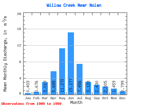
| Statistic | Jan | Feb | Mar | Apr | May | Jun | Jul | Aug | Sep | Oct | Nov | Dec | Annual |
|---|---|---|---|---|---|---|---|---|---|---|---|---|---|
| Mean | 0.40 | 0.68 | 3.02 | 5.69 | 11.27 | 15.18 | 7.46 | 3.13 | 2.43 | 2.00 | 1.46 | 0.80 | 4.52 |
| Standard Deviation | 0.42 | 0.59 | 2.48 | 4.88 | 10.90 | 17.69 | 9.45 | 4.02 | 3.74 | 2.29 | 1.57 | 0.97 | 3.29 |
| Min | 0.00 | 0.00 | 0.21 | 0.36 | 0.32 | 0.30 | 0.05 | 0.08 | 0.10 | 0.15 | 0.27 | 0.09 | 0.96 |
| Max | 1.47 | 1.92 | 11.60 | 21.20 | 55.80 | 88.30 | 44.00 | 25.60 | 20.70 | 14.50 | 5.53 | 3.02 | 10.96 |
| Coefficient of Variation | 1.04 | 0.88 | 0.82 | 0.86 | 0.97 | 1.17 | 1.27 | 1.28 | 1.54 | 1.14 | 1.08 | 1.21 | 0.73 |
 Return to R-Arctic Net Home Page