|
|
|||||||||||||||||
| Point ID: 259 | Downloads | Plots | Site Data | Code: 05BF004 |
|
|
|||||||||||||||||
| Download | |
|---|---|
| Site Descriptor Information | Site Time Series Data |
| Link to all available data | |
| View: | Time Series | All |
| Units: | mm |
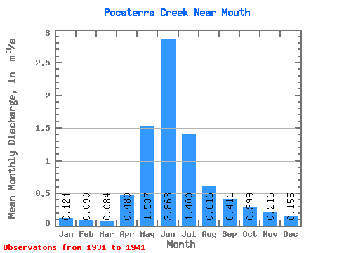
| Statistic | Jan | Feb | Mar | Apr | May | Jun | Jul | Aug | Sep | Oct | Nov | Dec | Annual |
|---|---|---|---|---|---|---|---|---|---|---|---|---|---|
| Mean | 0.12 | 0.09 | 0.08 | 0.48 | 1.54 | 2.86 | 1.40 | 0.62 | 0.41 | 0.30 | 0.22 | 0.15 | 0.88 |
| Standard Deviation | 0.01 | 0.01 | 0.01 | 0.52 | 0.91 | 1.47 | 0.54 | 0.26 | 0.23 | 0.15 | 0.11 | 0.02 | |
| Min | 0.12 | 0.09 | 0.08 | 0.15 | 0.82 | 1.21 | 0.56 | 0.28 | 0.21 | 0.12 | 0.05 | 0.14 | 0.88 |
| Max | 0.13 | 0.09 | 0.09 | 1.08 | 2.82 | 5.86 | 2.01 | 1.01 | 0.87 | 0.55 | 0.28 | 0.17 | 0.88 |
| Coefficient of Variation | 0.10 | 0.06 | 0.07 | 1.08 | 0.59 | 0.52 | 0.39 | 0.41 | 0.56 | 0.51 | 0.53 | 0.12 |
 Return to R-Arctic Net Home Page