|
|
|||||||||||||||||
| Point ID: 247 | Downloads | Plots | Site Data | Code: 05BD005 |
|
|
|||||||||||||||||
| Download | |
|---|---|
| Site Descriptor Information | Site Time Series Data |
| Link to all available data | |
| View: | Time Series | All |
| Units: | mm |
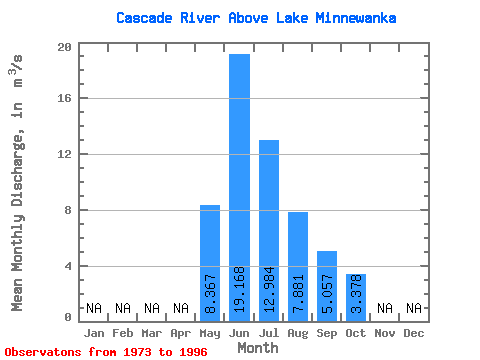
| Statistic | Jan | Feb | Mar | Apr | May | Jun | Jul | Aug | Sep | Oct | Nov | Dec | Annual |
|---|---|---|---|---|---|---|---|---|---|---|---|---|---|
| Mean | 8.37 | 19.17 | 12.98 | 7.88 | 5.06 | 3.38 | |||||||
| Standard Deviation | 3.39 | 6.78 | 4.57 | 2.35 | 1.14 | 0.46 | |||||||
| Min | 3.60 | 10.90 | 6.95 | 5.03 | 3.53 | 2.47 | |||||||
| Max | 16.10 | 33.50 | 24.00 | 12.80 | 8.16 | 4.32 | |||||||
| Coefficient of Variation | 0.41 | 0.35 | 0.35 | 0.30 | 0.23 | 0.14 |
 Return to R-Arctic Net Home Page