|
|
|||||||||||||||||
| Point ID: 246 | Downloads | Plots | Site Data | Code: 05BD004 |
|
|
|||||||||||||||||
| Download | |
|---|---|
| Site Descriptor Information | Site Time Series Data |
| Link to all available data | |
| View: | Time Series | All |
| Units: | mm |
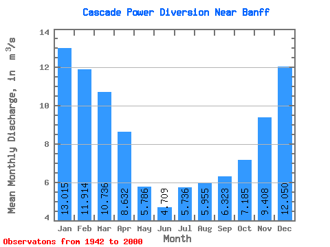
| Statistic | Jan | Feb | Mar | Apr | May | Jun | Jul | Aug | Sep | Oct | Nov | Dec | Annual |
|---|---|---|---|---|---|---|---|---|---|---|---|---|---|
| Mean | 13.02 | 11.91 | 10.74 | 8.63 | 5.79 | 4.71 | 5.74 | 5.96 | 6.32 | 7.18 | 9.41 | 12.05 | 8.42 |
| Standard Deviation | 4.10 | 4.43 | 4.38 | 4.55 | 3.75 | 5.74 | 7.18 | 4.86 | 4.24 | 4.21 | 3.98 | 3.56 | 1.71 |
| Min | 2.99 | 1.77 | 1.25 | 0.36 | 0.28 | 0.40 | 0.28 | 0.28 | 0.38 | 0.46 | 0.86 | 2.92 | 5.66 |
| Max | 24.30 | 20.80 | 19.20 | 19.30 | 14.40 | 24.90 | 27.60 | 20.30 | 16.40 | 21.40 | 18.20 | 18.60 | 13.67 |
| Coefficient of Variation | 0.32 | 0.37 | 0.41 | 0.53 | 0.65 | 1.22 | 1.25 | 0.82 | 0.67 | 0.59 | 0.42 | 0.30 | 0.20 |
 Return to R-Arctic Net Home Page