|
|
|||||||||||||||||
| Point ID: 238 | Downloads | Plots | Site Data | Code: 05BC001 |
|
|
|||||||||||||||||
| Download | |
|---|---|
| Site Descriptor Information | Site Time Series Data |
| Link to all available data | |
| View: | Time Series | All |
| Units: | mm |
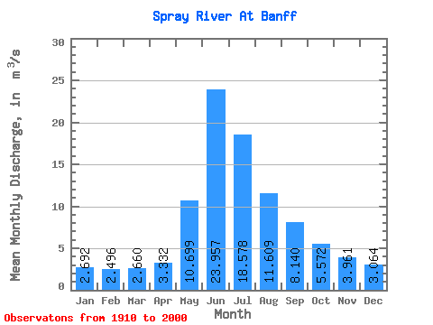
| Statistic | Jan | Feb | Mar | Apr | May | Jun | Jul | Aug | Sep | Oct | Nov | Dec | Annual |
|---|---|---|---|---|---|---|---|---|---|---|---|---|---|
| Mean | 2.69 | 2.50 | 2.66 | 3.33 | 10.70 | 23.96 | 18.58 | 11.61 | 8.14 | 5.57 | 3.96 | 3.06 | 8.04 |
| Standard Deviation | 1.57 | 1.66 | 2.72 | 3.43 | 8.95 | 20.37 | 15.71 | 7.88 | 5.49 | 3.96 | 2.58 | 1.86 | 5.67 |
| Min | 0.65 | 0.44 | 0.49 | 0.87 | 1.80 | 4.44 | 3.16 | 2.29 | 1.90 | 1.30 | 1.06 | 0.75 | 2.03 |
| Max | 6.14 | 12.00 | 24.90 | 29.40 | 35.90 | 71.50 | 66.40 | 32.20 | 24.80 | 15.90 | 9.77 | 6.74 | 20.08 |
| Coefficient of Variation | 0.58 | 0.67 | 1.02 | 1.03 | 0.84 | 0.85 | 0.85 | 0.68 | 0.67 | 0.71 | 0.65 | 0.61 | 0.71 |
 Return to R-Arctic Net Home Page