|
|
|||||||||||||||||
| Point ID: 230 | Downloads | Plots | Site Data | Code: 05BA008 |
|
|
|||||||||||||||||
| Download | |
|---|---|
| Site Descriptor Information | Site Time Series Data |
| Link to all available data | |
| View: | Time Series | All |
| Units: | mm |
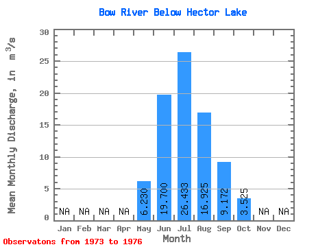
| Statistic | Jan | Feb | Mar | Apr | May | Jun | Jul | Aug | Sep | Oct | Nov | Dec | Annual |
|---|---|---|---|---|---|---|---|---|---|---|---|---|---|
| Mean | 6.23 | 19.70 | 26.43 | 16.93 | 9.17 | 3.52 | |||||||
| Standard Deviation | 3.88 | 7.39 | 1.40 | 3.78 | 3.99 | 0.55 | |||||||
| Min | 3.68 | 14.20 | 25.30 | 13.30 | 6.58 | 3.09 | |||||||
| Max | 10.70 | 28.10 | 28.00 | 22.00 | 15.00 | 4.33 | |||||||
| Coefficient of Variation | 0.62 | 0.38 | 0.05 | 0.22 | 0.43 | 0.16 |
 Return to R-Arctic Net Home Page