|
|
|||||||||||||||||
| Point ID: 222 | Downloads | Plots | Site Data | Code: 05AK001 |
|
|
|||||||||||||||||
| Download | |
|---|---|
| Site Descriptor Information | Site Time Series Data |
| Link to all available data | |
| View: | Time Series | All |
| Units: | mm |
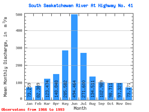
| Statistic | Jan | Feb | Mar | Apr | May | Jun | Jul | Aug | Sep | Oct | Nov | Dec | Annual |
|---|---|---|---|---|---|---|---|---|---|---|---|---|---|
| Mean | 73.26 | 82.39 | 123.47 | 148.85 | 285.58 | 494.46 | 271.60 | 134.51 | 102.99 | 98.71 | 97.32 | 73.17 | 164.09 |
| Standard Deviation | 20.21 | 20.81 | 44.75 | 66.15 | 163.77 | 286.87 | 183.20 | 91.33 | 69.21 | 53.83 | 29.52 | 22.61 | 62.62 |
| Min | 42.50 | 54.00 | 66.00 | 36.30 | 38.30 | 91.00 | 37.60 | 40.50 | 33.00 | 32.60 | 49.90 | 38.60 | 67.08 |
| Max | 119.00 | 126.00 | 243.00 | 338.00 | 628.00 | 1240.00 | 702.00 | 418.00 | 361.00 | 254.00 | 174.00 | 133.00 | 280.58 |
| Coefficient of Variation | 0.28 | 0.25 | 0.36 | 0.44 | 0.57 | 0.58 | 0.68 | 0.68 | 0.67 | 0.55 | 0.30 | 0.31 | 0.38 |
 Return to R-Arctic Net Home Page