|
|
|||||||||||||||||
| Point ID: 211 | Downloads | Plots | Site Data | Code: 05AH042 |
|
|
|||||||||||||||||
| Download | |
|---|---|
| Site Descriptor Information | Site Time Series Data |
| Link to all available data | |
| View: | Time Series | All |
| Units: | mm |
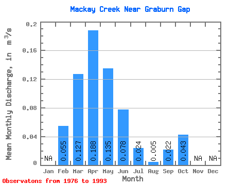
| Statistic | Jan | Feb | Mar | Apr | May | Jun | Jul | Aug | Sep | Oct | Nov | Dec | Annual |
|---|---|---|---|---|---|---|---|---|---|---|---|---|---|
| Mean | 0.06 | 0.13 | 0.19 | 0.14 | 0.08 | 0.02 | 0.01 | 0.02 | 0.04 | ||||
| Standard Deviation | 0.06 | 0.12 | 0.20 | 0.17 | 0.20 | 0.07 | 0.02 | 0.06 | 0.06 | ||||
| Min | 0.00 | 0.01 | 0.01 | 0.00 | 0.00 | 0.00 | 0.00 | 0.00 | 0.00 | ||||
| Max | 0.19 | 0.50 | 0.67 | 0.52 | 0.86 | 0.28 | 0.08 | 0.19 | 0.18 | ||||
| Coefficient of Variation | 1.18 | 0.98 | 1.05 | 1.26 | 2.58 | 2.73 | 3.66 | 2.76 | 1.30 |
 Return to R-Arctic Net Home Page