|
|
|||||||||||||||||
| Point ID: 203 | Downloads | Plots | Site Data | Code: 05AH032 |
|
|
|||||||||||||||||
| Download | |
|---|---|
| Site Descriptor Information | Site Time Series Data |
| Link to all available data | |
| View: | Time Series | All |
| Units: | mm |
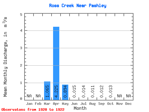
| Statistic | Jan | Feb | Mar | Apr | May | Jun | Jul | Aug | Sep | Oct | Nov | Dec | Annual |
|---|---|---|---|---|---|---|---|---|---|---|---|---|---|
| Mean | 1.06 | 4.22 | 0.89 | 0.01 | 0.01 | 0.01 | 0.01 | 0.01 | |||||
| Standard Deviation | 0.36 | 2.99 | 1.04 | 0.01 | 0.00 | 0.00 | 0.00 | 0.00 | |||||
| Min | 0.81 | 2.11 | 0.16 | 0.01 | 0.01 | 0.01 | 0.01 | 0.01 | |||||
| Max | 1.32 | 6.34 | 1.63 | 0.03 | 0.02 | 0.01 | 0.01 | 0.02 | |||||
| Coefficient of Variation | 0.34 | 0.71 | 1.16 | 0.68 | 0.23 | 0.36 | 0.25 | 0.23 |
 Return to R-Arctic Net Home Page