|
|
|||||||||||||||||
| Point ID: 198 | Downloads | Plots | Site Data | Code: 05AH009 |
|
|
|||||||||||||||||
| Download | |
|---|---|
| Site Descriptor Information | Site Time Series Data |
| Link to all available data | |
| View: | Time Series | All |
| Units: | mm |
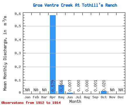
| Statistic | Jan | Feb | Mar | Apr | May | Jun | Jul | Aug | Sep | Oct | Nov | Dec | Annual |
|---|---|---|---|---|---|---|---|---|---|---|---|---|---|
| Mean | 0.58 | 0.07 | 0.01 | 0.00 | 0.00 | 0.00 | 0.02 | ||||||
| Standard Deviation | 0.30 | 0.04 | 0.01 | 0.00 | 0.00 | 0.00 | 0.03 | ||||||
| Min | 0.37 | 0.04 | 0.00 | 0.00 | 0.00 | 0.00 | 0.00 | ||||||
| Max | 0.79 | 0.11 | 0.02 | 0.00 | 0.00 | 0.00 | 0.06 | ||||||
| Coefficient of Variation | 0.51 | 0.61 | 1.02 | 1.73 | 1.73 | 1.56 |
 Return to R-Arctic Net Home Page