|
|
|||||||||||||||||
| Point ID: 193 | Downloads | Plots | Site Data | Code: 05AH002 |
|
|
|||||||||||||||||
| Download | |
|---|---|
| Site Descriptor Information | Site Time Series Data |
| Link to all available data | |
| View: | Time Series | All |
| Units: | mm |
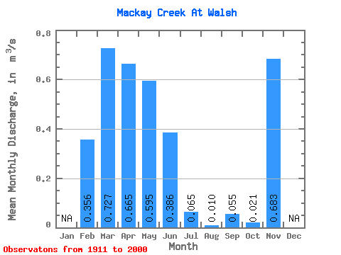
| Statistic | Jan | Feb | Mar | Apr | May | Jun | Jul | Aug | Sep | Oct | Nov | Dec | Annual |
|---|---|---|---|---|---|---|---|---|---|---|---|---|---|
| Mean | 0.36 | 0.73 | 0.67 | 0.59 | 0.39 | 0.07 | 0.01 | 0.06 | 0.02 | 0.68 | |||
| Standard Deviation | 0.70 | 0.96 | 0.79 | 1.27 | 0.99 | 0.18 | 0.06 | 0.29 | 0.07 | ||||
| Min | 0.00 | 0.00 | 0.00 | 0.00 | 0.00 | 0.00 | 0.00 | 0.00 | 0.00 | 0.68 | |||
| Max | 2.63 | 4.09 | 3.57 | 7.18 | 5.41 | 0.96 | 0.37 | 1.92 | 0.39 | 0.68 | |||
| Coefficient of Variation | 1.97 | 1.32 | 1.19 | 2.14 | 2.57 | 2.76 | 5.31 | 5.24 | 3.49 |
 Return to R-Arctic Net Home Page