|
|
|||||||||||||||||
| Point ID: 171 | Downloads | Plots | Site Data | Code: 05AF905 |
|
|
|||||||||||||||||
| Download | |
|---|---|
| Site Descriptor Information | Site Time Series Data |
| Link to all available data | |
| View: | Time Series | All |
| Units: | mm |
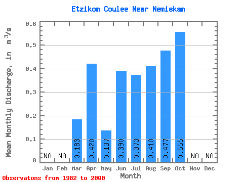
| Statistic | Jan | Feb | Mar | Apr | May | Jun | Jul | Aug | Sep | Oct | Nov | Dec | Annual |
|---|---|---|---|---|---|---|---|---|---|---|---|---|---|
| Mean | 0.18 | 0.42 | 0.14 | 0.39 | 0.37 | 0.41 | 0.48 | 0.56 | |||||
| Standard Deviation | 0.52 | 0.12 | 0.86 | 0.46 | 0.65 | 0.52 | 0.46 | ||||||
| Min | 0.18 | 0.05 | 0.00 | 0.00 | 0.00 | 0.00 | 0.00 | 0.00 | |||||
| Max | 0.18 | 1.77 | 0.33 | 3.64 | 1.40 | 2.68 | 1.87 | 1.67 | |||||
| Coefficient of Variation | 1.23 | 0.83 | 2.21 | 1.23 | 1.59 | 1.09 | 0.83 |
 Return to R-Arctic Net Home Page