|
|
|||||||||||||||||
| Point ID: 17 | Downloads | Plots | Site Data | Code: 05AA022 |
|
|
|||||||||||||||||
| Download | |
|---|---|
| Site Descriptor Information | Site Time Series Data |
| Link to all available data | |
| View: | Time Series | All |
| Units: | mm |
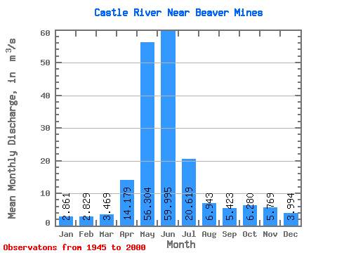
| Statistic | Jan | Feb | Mar | Apr | May | Jun | Jul | Aug | Sep | Oct | Nov | Dec | Annual |
|---|---|---|---|---|---|---|---|---|---|---|---|---|---|
| Mean | 2.86 | 2.83 | 3.47 | 14.18 | 56.30 | 59.99 | 20.62 | 6.94 | 5.42 | 6.28 | 5.77 | 3.99 | 15.77 |
| Standard Deviation | 1.23 | 1.39 | 2.37 | 7.33 | 15.95 | 27.44 | 9.83 | 3.06 | 3.74 | 5.03 | 4.17 | 2.55 | 4.29 |
| Min | 1.43 | 0.90 | 1.36 | 2.67 | 20.50 | 12.90 | 4.18 | 3.31 | 2.56 | 2.25 | 1.32 | 1.70 | 5.50 |
| Max | 7.24 | 7.66 | 15.40 | 31.20 | 93.20 | 126.00 | 46.50 | 19.30 | 25.50 | 27.60 | 21.10 | 13.60 | 27.02 |
| Coefficient of Variation | 0.43 | 0.49 | 0.68 | 0.52 | 0.28 | 0.46 | 0.48 | 0.44 | 0.69 | 0.80 | 0.72 | 0.64 | 0.27 |
 Return to R-Arctic Net Home Page