|
|
|||||||||||||||||
| Point ID: 168 | Downloads | Plots | Site Data | Code: 05AF029 |
|
|
|||||||||||||||||
| Download | |
|---|---|
| Site Descriptor Information | Site Time Series Data |
| Link to all available data | |
| View: | Time Series | All |
| Units: | mm |
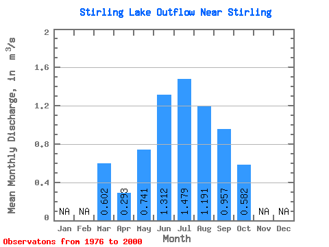
| Statistic | Jan | Feb | Mar | Apr | May | Jun | Jul | Aug | Sep | Oct | Nov | Dec | Annual |
|---|---|---|---|---|---|---|---|---|---|---|---|---|---|
| Mean | 0.60 | 0.29 | 0.74 | 1.31 | 1.48 | 1.19 | 0.96 | 0.58 | |||||
| Standard Deviation | 0.95 | 0.41 | 0.41 | 0.59 | 0.43 | 0.30 | 0.41 | 0.19 | |||||
| Min | 0.03 | 0.06 | 0.22 | 0.34 | 0.52 | 0.53 | 0.38 | 0.31 | |||||
| Max | 3.42 | 1.81 | 1.61 | 2.73 | 2.34 | 1.70 | 1.98 | 1.19 | |||||
| Coefficient of Variation | 1.59 | 1.40 | 0.56 | 0.45 | 0.29 | 0.25 | 0.43 | 0.33 |
 Return to R-Arctic Net Home Page