|
|
|||||||||||||||||
| Point ID: 167 | Downloads | Plots | Site Data | Code: 05AF028 |
|
|
|||||||||||||||||
| Download | |
|---|---|
| Site Descriptor Information | Site Time Series Data |
| Link to all available data | |
| View: | Time Series | All |
| Units: | mm |
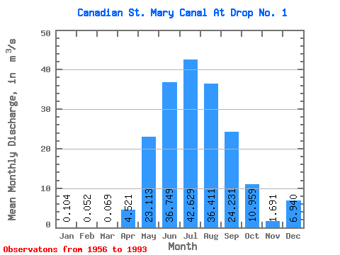
| Statistic | Jan | Feb | Mar | Apr | May | Jun | Jul | Aug | Sep | Oct | Nov | Dec | Annual |
|---|---|---|---|---|---|---|---|---|---|---|---|---|---|
| Mean | 0.10 | 0.05 | 0.07 | 4.52 | 23.11 | 36.75 | 42.63 | 36.41 | 24.23 | 10.96 | 1.69 | 6.94 | |
| Standard Deviation | 0.09 | 8.48 | 18.20 | 17.70 | 17.48 | 10.90 | 10.48 | 6.22 | 3.66 | ||||
| Min | 0.10 | 0.05 | 0.00 | 0.00 | 0.14 | 6.92 | 8.64 | 9.51 | 6.65 | 3.01 | 0.00 | 6.94 | |
| Max | 0.10 | 0.05 | 0.26 | 36.60 | 75.40 | 67.60 | 71.10 | 59.70 | 51.70 | 26.50 | 10.30 | 6.94 | |
| Coefficient of Variation | 1.36 | 1.88 | 0.79 | 0.48 | 0.41 | 0.30 | 0.43 | 0.57 | 2.16 |
 Return to R-Arctic Net Home Page