|
|
|||||||||||||||||
| Point ID: 150 | Downloads | Plots | Site Data | Code: 05AE039 |
|
|
|||||||||||||||||
| Download | |
|---|---|
| Site Descriptor Information | Site Time Series Data |
| Link to all available data | |
| View: | Time Series | All |
| Units: | mm |
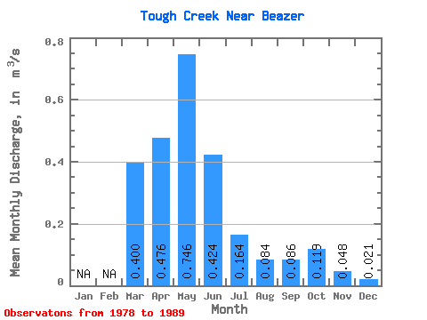
| Statistic | Jan | Feb | Mar | Apr | May | Jun | Jul | Aug | Sep | Oct | Nov | Dec | Annual |
|---|---|---|---|---|---|---|---|---|---|---|---|---|---|
| Mean | 0.40 | 0.48 | 0.75 | 0.42 | 0.16 | 0.08 | 0.09 | 0.12 | 0.05 | 0.02 | |||
| Standard Deviation | 0.28 | 0.22 | 0.63 | 0.29 | 0.14 | 0.09 | 0.08 | 0.14 | |||||
| Min | 0.20 | 0.24 | 0.10 | 0.09 | 0.03 | 0.01 | 0.01 | 0.01 | 0.05 | 0.02 | |||
| Max | 0.60 | 0.80 | 2.41 | 0.96 | 0.49 | 0.31 | 0.25 | 0.49 | 0.05 | 0.02 | |||
| Coefficient of Variation | 0.71 | 0.46 | 0.85 | 0.70 | 0.86 | 1.05 | 0.96 | 1.20 |
 Return to R-Arctic Net Home Page