|
|
|||||||||||||||||
| Point ID: 147 | Downloads | Plots | Site Data | Code: 05AE033 |
|
|
|||||||||||||||||
| Download | |
|---|---|
| Site Descriptor Information | Site Time Series Data |
| Link to all available data | |
| View: | Time Series | All |
| Units: | mm |
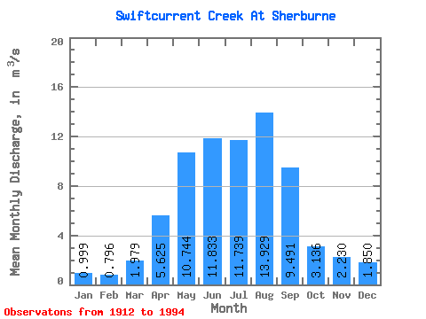
| Statistic | Jan | Feb | Mar | Apr | May | Jun | Jul | Aug | Sep | Oct | Nov | Dec | Annual |
|---|---|---|---|---|---|---|---|---|---|---|---|---|---|
| Mean | 1.00 | 0.80 | 1.98 | 5.62 | 10.74 | 11.83 | 11.74 | 13.93 | 9.49 | 3.14 | 2.23 | 1.85 | 5.40 |
| Standard Deviation | 0.27 | 0.50 | 3.32 | 5.16 | 5.78 | 6.91 | 3.89 | 4.60 | 6.29 | 3.79 | 0.82 | 1.13 | 1.29 |
| Min | 0.56 | 0.14 | 0.00 | 0.01 | 0.31 | 0.51 | 2.00 | 2.16 | 0.01 | 0.00 | 1.03 | 0.89 | 4.26 |
| Max | 1.28 | 1.88 | 11.50 | 18.20 | 29.30 | 30.40 | 21.50 | 21.40 | 22.40 | 16.30 | 3.61 | 4.17 | 6.80 |
| Coefficient of Variation | 0.27 | 0.63 | 1.68 | 0.92 | 0.54 | 0.58 | 0.33 | 0.33 | 0.66 | 1.21 | 0.37 | 0.61 | 0.24 |
 Return to R-Arctic Net Home Page