|
|
|||||||||||||||||
| Point ID: 142 | Downloads | Plots | Site Data | Code: 05AE028 |
|
|
|||||||||||||||||
| Download | |
|---|---|
| Site Descriptor Information | Site Time Series Data |
| Link to all available data | |
| View: | Time Series | All |
| Units: | mm |
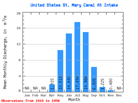
| Statistic | Jan | Feb | Mar | Apr | May | Jun | Jul | Aug | Sep | Oct | Nov | Dec | Annual |
|---|---|---|---|---|---|---|---|---|---|---|---|---|---|
| Mean | 1.92 | 10.51 | 14.64 | 17.49 | 14.98 | 6.30 | 1.23 | 0.48 | |||||
| Standard Deviation | 2.96 | 6.88 | 4.13 | 3.90 | 4.63 | 5.66 | 2.74 | 1.54 | |||||
| Min | 0.00 | 0.00 | 5.33 | 10.10 | 3.28 | 0.00 | 0.00 | 0.00 | |||||
| Max | 12.40 | 21.00 | 22.80 | 24.50 | 22.50 | 16.50 | 15.20 | 7.17 | |||||
| Coefficient of Variation | 1.54 | 0.65 | 0.28 | 0.22 | 0.31 | 0.90 | 2.24 | 3.20 |
 Return to R-Arctic Net Home Page