|
|
|||||||||||||||||
| Point ID: 133 | Downloads | Plots | Site Data | Code: 05AE015 |
|
|
|||||||||||||||||
| Download | |
|---|---|
| Site Descriptor Information | Site Time Series Data |
| Link to all available data | |
| View: | Time Series | All |
| Units: | mm |
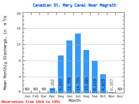
| Statistic | Jan | Feb | Mar | Apr | May | Jun | Jul | Aug | Sep | Oct | Nov | Dec | Annual |
|---|---|---|---|---|---|---|---|---|---|---|---|---|---|
| Mean | 1.15 | 9.30 | 12.99 | 14.73 | 10.68 | 8.01 | 4.62 | 0.16 | |||||
| Standard Deviation | 1.41 | 4.90 | 5.53 | 4.21 | 2.56 | 2.28 | 2.51 | 0.17 | |||||
| Min | 0.00 | 0.50 | 1.54 | 3.24 | 6.38 | 2.33 | 0.64 | 0.00 | |||||
| Max | 4.94 | 19.80 | 21.50 | 21.60 | 17.60 | 13.50 | 11.30 | 0.33 | |||||
| Coefficient of Variation | 1.23 | 0.53 | 0.42 | 0.29 | 0.24 | 0.28 | 0.54 | 1.10 |
 Return to R-Arctic Net Home Page