|
|
|||||||||||||||||
| Point ID: 132 | Downloads | Plots | Site Data | Code: 05AE014 |
|
|
|||||||||||||||||
| Download | |
|---|---|
| Site Descriptor Information | Site Time Series Data |
| Link to all available data | |
| View: | Time Series | All |
| Units: | mm |
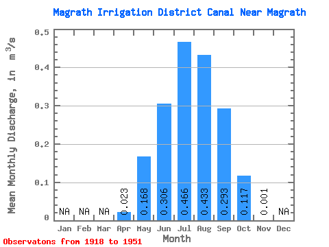
| Statistic | Jan | Feb | Mar | Apr | May | Jun | Jul | Aug | Sep | Oct | Nov | Dec | Annual |
|---|---|---|---|---|---|---|---|---|---|---|---|---|---|
| Mean | 0.02 | 0.17 | 0.31 | 0.47 | 0.43 | 0.29 | 0.12 | 0.00 | |||||
| Standard Deviation | 0.01 | 0.15 | 0.19 | 0.20 | 0.14 | 0.12 | 0.09 | ||||||
| Min | 0.02 | 0.00 | 0.00 | 0.00 | 0.17 | 0.00 | 0.01 | 0.00 | |||||
| Max | 0.03 | 0.50 | 0.64 | 0.85 | 0.81 | 0.49 | 0.33 | 0.00 | |||||
| Coefficient of Variation | 0.43 | 0.92 | 0.61 | 0.44 | 0.34 | 0.42 | 0.77 |
 Return to R-Arctic Net Home Page