|
|
|||||||||||||||||
| Point ID: 127 | Downloads | Plots | Site Data | Code: 05AE008 |
|
|
|||||||||||||||||
| Download | |
|---|---|
| Site Descriptor Information | Site Time Series Data |
| Link to all available data | |
| View: | Time Series | All |
| Units: | mm |
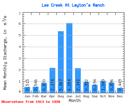
| Statistic | Jan | Feb | Mar | Apr | May | Jun | Jul | Aug | Sep | Oct | Nov | Dec | Annual |
|---|---|---|---|---|---|---|---|---|---|---|---|---|---|
| Mean | 0.52 | 0.55 | 0.87 | 2.17 | 5.37 | 6.05 | 2.14 | 0.93 | 0.69 | 1.05 | 0.90 | 0.45 | 1.82 |
| Standard Deviation | 0.28 | 0.52 | 0.81 | 0.80 | 2.70 | 4.52 | 1.72 | 0.85 | 0.64 | 0.86 | 0.60 | 0.30 | 1.07 |
| Min | 0.30 | 0.26 | 0.39 | 1.18 | 1.73 | 0.90 | 0.18 | 0.12 | 0.09 | 0.25 | 0.21 | 0.15 | 0.49 |
| Max | 1.11 | 1.72 | 2.67 | 3.69 | 8.54 | 13.40 | 5.05 | 2.60 | 2.02 | 2.58 | 1.69 | 1.02 | 3.26 |
| Coefficient of Variation | 0.53 | 0.96 | 0.93 | 0.37 | 0.50 | 0.75 | 0.80 | 0.91 | 0.92 | 0.82 | 0.67 | 0.68 | 0.59 |
 Return to R-Arctic Net Home Page