|
|
|||||||||||||||||
| Point ID: 123 | Downloads | Plots | Site Data | Code: 05AE004 |
|
|
|||||||||||||||||
| Download | |
|---|---|
| Site Descriptor Information | Site Time Series Data |
| Link to all available data | |
| View: | Time Series | All |
| Units: | mm |
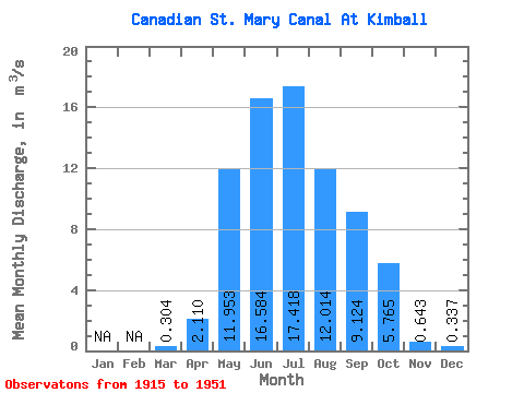
| Statistic | Jan | Feb | Mar | Apr | May | Jun | Jul | Aug | Sep | Oct | Nov | Dec | Annual |
|---|---|---|---|---|---|---|---|---|---|---|---|---|---|
| Mean | 0.30 | 2.11 | 11.95 | 16.58 | 17.42 | 12.01 | 9.12 | 5.76 | 0.64 | 0.34 | |||
| Standard Deviation | 1.98 | 5.23 | 5.94 | 5.33 | 3.18 | 2.75 | 3.77 | 2.09 | 0.04 | ||||
| Min | 0.30 | 0.00 | 3.02 | 5.33 | 4.01 | 5.64 | 2.20 | 0.00 | 0.00 | 0.31 | |||
| Max | 0.30 | 6.14 | 24.00 | 25.50 | 29.80 | 20.70 | 16.80 | 15.60 | 11.90 | 0.37 | |||
| Coefficient of Variation | 0.94 | 0.44 | 0.36 | 0.31 | 0.27 | 0.30 | 0.66 | 3.26 | 0.12 |
 Return to R-Arctic Net Home Page