|
|
|||||||||||||||||
| Point ID: 12 | Downloads | Plots | Site Data | Code: 05AA013 |
|
|
|||||||||||||||||
| Download | |
|---|---|
| Site Descriptor Information | Site Time Series Data |
| Link to all available data | |
| View: | Time Series | All |
| Units: | mm |
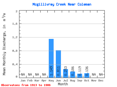
| Statistic | Jan | Feb | Mar | Apr | May | Jun | Jul | Aug | Sep | Oct | Nov | Dec | Annual |
|---|---|---|---|---|---|---|---|---|---|---|---|---|---|
| Mean | 1.15 | 0.81 | 0.25 | 0.19 | 0.12 | 0.14 | |||||||
| Standard Deviation | 0.61 | 0.31 | 0.14 | 0.25 | 0.06 | 0.11 | |||||||
| Min | 0.37 | 0.27 | 0.08 | 0.07 | 0.06 | 0.05 | |||||||
| Max | 2.49 | 1.25 | 0.55 | 0.95 | 0.23 | 0.44 | |||||||
| Coefficient of Variation | 0.54 | 0.39 | 0.54 | 1.32 | 0.53 | 0.81 |
 Return to R-Arctic Net Home Page