|
|
|||||||||||||||||
| Point ID: 114 | Downloads | Plots | Site Data | Code: 05AD038 |
|
|
|||||||||||||||||
| Download | |
|---|---|
| Site Descriptor Information | Site Time Series Data |
| Link to all available data | |
| View: | Time Series | All |
| Units: | mm |
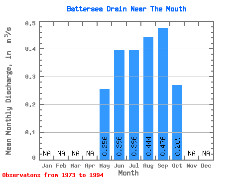
| Statistic | Jan | Feb | Mar | Apr | May | Jun | Jul | Aug | Sep | Oct | Nov | Dec | Annual |
|---|---|---|---|---|---|---|---|---|---|---|---|---|---|
| Mean | 0.26 | 0.40 | 0.40 | 0.44 | 0.48 | 0.27 | |||||||
| Standard Deviation | 0.19 | 0.12 | 0.14 | 0.16 | 0.17 | 0.12 | |||||||
| Min | 0.02 | 0.15 | 0.10 | 0.15 | 0.23 | 0.06 | |||||||
| Max | 0.67 | 0.60 | 0.63 | 0.86 | 0.96 | 0.50 | |||||||
| Coefficient of Variation | 0.75 | 0.31 | 0.35 | 0.37 | 0.35 | 0.43 |
 Return to R-Arctic Net Home Page