|
|
|||||||||||||||||
| Point ID: 9734 | Downloads | Plots | Site Data | Code: 05100000 |
|
|
|||||||||||||||||
| Download | |
|---|---|
| Site Descriptor Information | Site Time Series Data |
| Link to all available data | |
| View: | Time Series | All |
| Units: | m3/s |
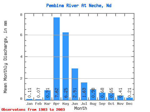
| Statistic | Jan | Feb | Mar | Apr | May | Jun | Jul | Aug | Sep | Oct | Nov | Dec | Annual |
|---|---|---|---|---|---|---|---|---|---|---|---|---|---|
| Mean | 0.11 | 0.07 | 0.91 | 7.62 | 6.24 | 2.91 | 1.63 | 0.98 | 0.68 | 0.65 | 0.41 | 0.21 | 23.06 |
| Standard Deviation | 0.15 | 0.09 | 1.66 | 8.51 | 8.17 | 3.19 | 2.00 | 1.45 | 0.87 | 0.78 | 0.52 | 0.30 | 22.40 |
| Min | 0.00 | 0.00 | 0.00 | 0.20 | 0.10 | 0.06 | 0.00 | 0.00 | 0.00 | 0.00 | 0.00 | 0.00 | 0.40 |
| Max | 1.03 | 0.52 | 10.44 | 39.17 | 40.96 | 15.74 | 12.95 | 8.12 | 5.39 | 5.53 | 4.04 | 2.24 | 106.46 |
| Coefficient of Variation | 1.35 | 1.29 | 1.83 | 1.12 | 1.31 | 1.10 | 1.23 | 1.48 | 1.28 | 1.20 | 1.28 | 1.43 | 0.97 |
 Return to R-Arctic Net Home Page