|
|
|||||||||||||||||
| Point ID: 9730 | Downloads | Plots | Site Data | Code: 05059500 |
|
|
|||||||||||||||||
| Download | |
|---|---|
| Site Descriptor Information | Site Time Series Data |
| Link to all available data | |
| View: | Time Series | All |
| Units: | m3/s |
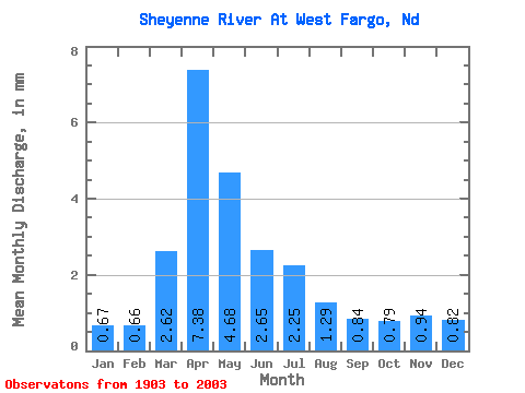
| Statistic | Jan | Feb | Mar | Apr | May | Jun | Jul | Aug | Sep | Oct | Nov | Dec | Annual |
|---|---|---|---|---|---|---|---|---|---|---|---|---|---|
| Mean | 0.23 | 0.23 | 0.91 | 2.57 | 1.63 | 0.92 | 0.78 | 0.45 | 0.29 | 0.28 | 0.33 | 0.29 | 8.95 |
| Standard Deviation | 0.21 | 0.21 | 1.01 | 2.30 | 2.01 | 0.90 | 0.99 | 0.87 | 0.39 | 0.32 | 0.39 | 0.30 | 7.25 |
| Min | 0.02 | 0.02 | 0.02 | 0.21 | 0.18 | 0.08 | 0.05 | 0.03 | 0.02 | 0.03 | 0.04 | 0.03 | 1.45 |
| Max | 0.91 | 0.96 | 3.91 | 10.58 | 10.68 | 5.70 | 4.53 | 7.32 | 1.94 | 2.35 | 2.19 | 1.54 | 30.80 |
| Coefficient of Variation | 0.90 | 0.89 | 1.10 | 0.90 | 1.23 | 0.98 | 1.26 | 1.93 | 1.32 | 1.14 | 1.19 | 1.04 | 0.81 |
 Return to R-Arctic Net Home Page