|
|
|||||||||||||||||
| Point ID: 9721 | Downloads | Plots | Site Data | Code: 05127500 |
|
|
|||||||||||||||||
| Download | |
|---|---|
| Site Descriptor Information | Site Time Series Data |
| Link to all available data | |
| View: | Time Series | All |
| Units: | m3/s |
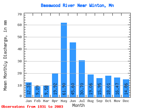
| Statistic | Jan | Feb | Mar | Apr | May | Jun | Jul | Aug | Sep | Oct | Nov | Dec | Annual |
|---|---|---|---|---|---|---|---|---|---|---|---|---|---|
| Mean | 12.30 | 9.16 | 9.58 | 19.92 | 61.89 | 45.60 | 30.70 | 19.06 | 15.95 | 18.00 | 16.47 | 14.86 | 274.88 |
| Standard Deviation | 5.66 | 3.65 | 3.29 | 12.51 | 31.23 | 22.67 | 14.60 | 11.98 | 12.94 | 16.40 | 13.26 | 8.91 | 78.50 |
| Min | 1.45 | 1.46 | 2.27 | 4.38 | 3.78 | 11.33 | 8.61 | 4.68 | 1.96 | 1.09 | 0.98 | 1.28 | 132.14 |
| Max | 24.83 | 18.84 | 19.23 | 82.56 | 153.36 | 119.41 | 74.93 | 58.67 | 81.99 | 89.52 | 63.18 | 42.24 | 506.03 |
| Coefficient of Variation | 0.46 | 0.40 | 0.34 | 0.63 | 0.51 | 0.50 | 0.48 | 0.63 | 0.81 | 0.91 | 0.81 | 0.60 | 0.29 |
 Return to R-Arctic Net Home Page