|
|
|||||||||||||||||
| Point ID: 9720 | Downloads | Plots | Site Data | Code: 05107500 |
|
|
|||||||||||||||||
| Download | |
|---|---|
| Site Descriptor Information | Site Time Series Data |
| Link to all available data | |
| View: | Time Series | All |
| Units: | m3/s |
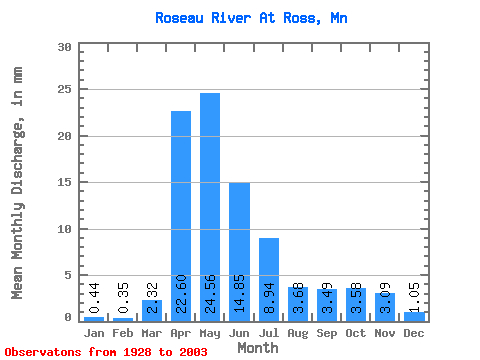
| Statistic | Jan | Feb | Mar | Apr | May | Jun | Jul | Aug | Sep | Oct | Nov | Dec | Annual |
|---|---|---|---|---|---|---|---|---|---|---|---|---|---|
| Mean | 0.44 | 0.35 | 2.32 | 22.61 | 24.56 | 14.85 | 8.94 | 3.68 | 3.49 | 3.58 | 3.09 | 1.05 | 89.87 |
| Standard Deviation | 0.33 | 0.36 | 3.48 | 16.58 | 25.01 | 18.14 | 11.04 | 7.06 | 5.73 | 5.08 | 6.15 | 1.37 | 58.74 |
| Min | 0.00 | 0.00 | 0.07 | 0.83 | 0.79 | 0.18 | 0.04 | 0.02 | 0.01 | 0.05 | 0.04 | 0.01 | 10.07 |
| Max | 1.79 | 2.43 | 14.81 | 84.07 | 123.09 | 118.36 | 61.78 | 36.33 | 27.06 | 26.17 | 50.07 | 10.61 | 243.50 |
| Coefficient of Variation | 0.75 | 1.01 | 1.50 | 0.73 | 1.02 | 1.22 | 1.23 | 1.92 | 1.64 | 1.42 | 1.99 | 1.31 | 0.65 |
 Return to R-Arctic Net Home Page