|
|
|||||||||||||||||
| Point ID: 9718 | Downloads | Plots | Site Data | Code: 05066500 |
|
|
|||||||||||||||||
| Download | |
|---|---|
| Site Descriptor Information | Site Time Series Data |
| Link to all available data | |
| View: | Time Series | All |
| Units: | m3/s |
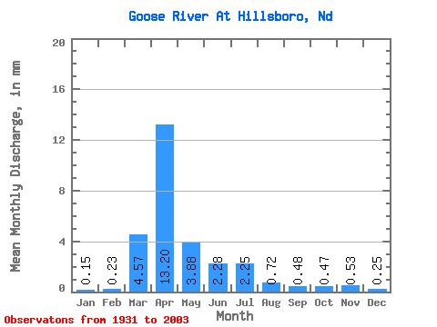
| Statistic | Jan | Feb | Mar | Apr | May | Jun | Jul | Aug | Sep | Oct | Nov | Dec | Annual |
|---|---|---|---|---|---|---|---|---|---|---|---|---|---|
| Mean | 0.14 | 0.21 | 4.15 | 11.99 | 3.52 | 2.07 | 2.04 | 0.65 | 0.44 | 0.42 | 0.48 | 0.22 | 27.37 |
| Standard Deviation | 0.21 | 0.64 | 6.39 | 16.30 | 7.74 | 3.26 | 4.17 | 1.71 | 1.13 | 1.31 | 1.43 | 0.36 | 28.73 |
| Min | 0.00 | 0.00 | 0.00 | 0.15 | 0.03 | 0.03 | 0.00 | 0.00 | 0.00 | 0.00 | 0.00 | 0.00 | 1.00 |
| Max | 1.15 | 4.82 | 29.68 | 80.37 | 55.36 | 22.48 | 19.99 | 12.53 | 7.68 | 10.62 | 11.05 | 1.94 | 114.73 |
| Coefficient of Variation | 1.55 | 3.04 | 1.54 | 1.36 | 2.20 | 1.58 | 2.04 | 2.62 | 2.59 | 3.09 | 2.96 | 1.61 | 1.05 |
 Return to R-Arctic Net Home Page