|
|
|||||||||||||||||
| Point ID: 9708 | Downloads | Plots | Site Data | Code: 05078000 |
|
|
|||||||||||||||||
| Download | |
|---|---|
| Site Descriptor Information | Site Time Series Data |
| Link to all available data | |
| View: | Time Series | All |
| Units: | m3/s |
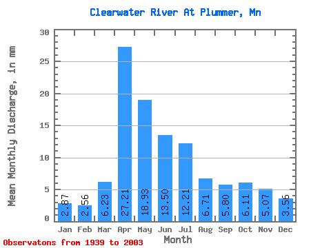
| Statistic | Jan | Feb | Mar | Apr | May | Jun | Jul | Aug | Sep | Oct | Nov | Dec | Annual |
|---|---|---|---|---|---|---|---|---|---|---|---|---|---|
| Mean | 2.87 | 2.59 | 6.23 | 27.21 | 18.93 | 13.50 | 12.21 | 6.71 | 5.80 | 6.11 | 5.07 | 3.56 | 111.67 |
| Standard Deviation | 1.05 | 1.33 | 5.29 | 19.88 | 16.69 | 11.22 | 10.85 | 5.39 | 5.97 | 4.96 | 4.83 | 1.65 | 45.08 |
| Min | 0.97 | 0.92 | 1.20 | 1.37 | 0.40 | 1.54 | 0.85 | 0.70 | 0.72 | 1.13 | 1.22 | 1.29 | 34.62 |
| Max | 6.62 | 8.86 | 23.47 | 75.16 | 104.14 | 58.19 | 56.54 | 26.74 | 34.03 | 25.49 | 31.51 | 11.16 | 221.28 |
| Coefficient of Variation | 0.37 | 0.52 | 0.85 | 0.73 | 0.88 | 0.83 | 0.89 | 0.80 | 1.03 | 0.81 | 0.95 | 0.46 | 0.40 |
 Return to R-Arctic Net Home Page