|
|
|||||||||||||||||
| Point ID: 9706 | Downloads | Plots | Site Data | Code: 05130500 |
|
|
|||||||||||||||||
| Download | |
|---|---|
| Site Descriptor Information | Site Time Series Data |
| Link to all available data | |
| View: | Time Series | All |
| Units: | m3/s |
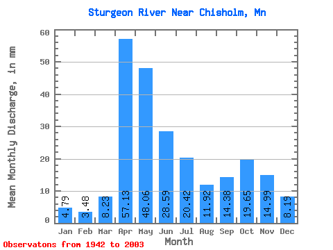
| Statistic | Jan | Feb | Mar | Apr | May | Jun | Jul | Aug | Sep | Oct | Nov | Dec | Annual |
|---|---|---|---|---|---|---|---|---|---|---|---|---|---|
| Mean | 4.79 | 3.51 | 8.23 | 57.13 | 48.05 | 28.59 | 20.42 | 11.92 | 14.38 | 19.65 | 14.99 | 8.18 | 241.69 |
| Standard Deviation | 2.29 | 1.51 | 8.71 | 29.02 | 32.79 | 16.35 | 18.87 | 9.46 | 12.42 | 17.30 | 9.33 | 4.68 | 63.05 |
| Min | 0.65 | 0.67 | 1.63 | 6.46 | 3.73 | 2.31 | 0.98 | 2.04 | 0.72 | 1.28 | 1.40 | 0.78 | 117.68 |
| Max | 10.74 | 7.07 | 54.83 | 136.66 | 235.94 | 83.07 | 101.27 | 43.54 | 66.81 | 97.63 | 41.53 | 21.97 | 368.06 |
| Coefficient of Variation | 0.48 | 0.43 | 1.06 | 0.51 | 0.68 | 0.57 | 0.92 | 0.79 | 0.86 | 0.88 | 0.62 | 0.57 | 0.26 |
 Return to R-Arctic Net Home Page