|
|
|||||||||||||||||
| Point ID: 9704 | Downloads | Plots | Site Data | Code: 05094000 |
|
|
|||||||||||||||||
| Download | |
|---|---|
| Site Descriptor Information | Site Time Series Data |
| Link to all available data | |
| View: | Time Series | All |
| Units: | m3/s |
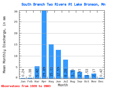
| Statistic | Jan | Feb | Mar | Apr | May | Jun | Jul | Aug | Sep | Oct | Nov | Dec | Annual |
|---|---|---|---|---|---|---|---|---|---|---|---|---|---|
| Mean | 0.24 | 0.38 | 5.42 | 29.89 | 15.11 | 12.59 | 8.28 | 3.70 | 2.97 | 1.53 | 2.17 | 0.42 | 87.30 |
| Standard Deviation | 0.23 | 0.87 | 8.90 | 30.59 | 21.37 | 19.43 | 15.17 | 12.46 | 6.72 | 2.45 | 9.80 | 0.52 | 69.60 |
| Min | 0.01 | 0.01 | 0.05 | 0.04 | 0.07 | 0.10 | 0.03 | 0.01 | 0.00 | 0.03 | 0.03 | 0.01 | 2.86 |
| Max | 1.06 | 5.89 | 47.84 | 132.78 | 104.09 | 89.70 | 78.83 | 93.58 | 35.23 | 10.62 | 76.04 | 2.63 | 247.91 |
| Coefficient of Variation | 0.93 | 2.28 | 1.64 | 1.02 | 1.41 | 1.54 | 1.83 | 3.37 | 2.27 | 1.60 | 4.51 | 1.23 | 0.80 |
 Return to R-Arctic Net Home Page