|
|
|||||||||||||||||
| Point ID: 9702 | Downloads | Plots | Site Data | Code: 05085000 |
|
|
|||||||||||||||||
| Download | |
|---|---|
| Site Descriptor Information | Site Time Series Data |
| Link to all available data | |
| View: | Time Series | All |
| Units: | m3/s |
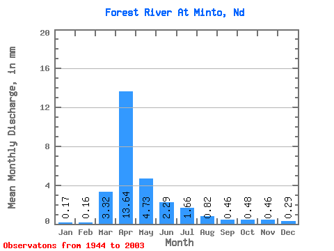
| Statistic | Jan | Feb | Mar | Apr | May | Jun | Jul | Aug | Sep | Oct | Nov | Dec | Annual |
|---|---|---|---|---|---|---|---|---|---|---|---|---|---|
| Mean | 0.14 | 0.13 | 2.78 | 11.43 | 3.96 | 1.92 | 1.39 | 0.69 | 0.39 | 0.40 | 0.39 | 0.24 | 24.18 |
| Standard Deviation | 0.15 | 0.26 | 3.92 | 12.84 | 8.34 | 2.18 | 2.21 | 1.74 | 0.52 | 0.35 | 0.24 | 0.19 | 21.84 |
| Min | 0.00 | 0.00 | 0.00 | 0.68 | 0.42 | 0.16 | 0.07 | 0.00 | 0.00 | 0.00 | 0.04 | 0.01 | 1.99 |
| Max | 0.62 | 1.81 | 17.34 | 60.24 | 59.96 | 10.21 | 13.79 | 12.96 | 2.64 | 2.34 | 1.24 | 0.83 | 124.82 |
| Coefficient of Variation | 1.08 | 1.98 | 1.41 | 1.12 | 2.11 | 1.14 | 1.59 | 2.53 | 1.34 | 0.88 | 0.61 | 0.77 | 0.90 |
 Return to R-Arctic Net Home Page