|
|
|||||||||||||||||
| Point ID: 9701 | Downloads | Plots | Site Data | Code: 05069000 |
|
|
|||||||||||||||||
| Download | |
|---|---|
| Site Descriptor Information | Site Time Series Data |
| Link to all available data | |
| View: | Time Series | All |
| Units: | m3/s |
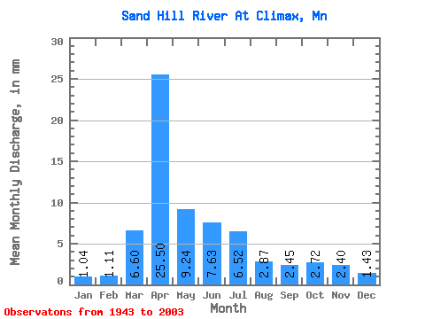
| Statistic | Jan | Feb | Mar | Apr | May | Jun | Jul | Aug | Sep | Oct | Nov | Dec | Annual |
|---|---|---|---|---|---|---|---|---|---|---|---|---|---|
| Mean | 1.04 | 1.12 | 6.60 | 25.50 | 9.24 | 7.63 | 6.52 | 2.87 | 2.45 | 2.72 | 2.40 | 1.43 | 69.78 |
| Standard Deviation | 0.58 | 1.54 | 8.95 | 23.25 | 11.38 | 8.59 | 8.70 | 4.47 | 3.76 | 2.77 | 2.94 | 0.87 | 45.10 |
| Min | 0.14 | 0.23 | 0.41 | 1.71 | 1.65 | 0.78 | 0.62 | 0.44 | 0.44 | 0.66 | 0.58 | 0.36 | 17.03 |
| Max | 2.56 | 11.62 | 42.55 | 105.77 | 80.61 | 46.52 | 49.01 | 29.71 | 25.21 | 15.58 | 19.14 | 4.05 | 206.56 |
| Coefficient of Variation | 0.56 | 1.37 | 1.36 | 0.91 | 1.23 | 1.13 | 1.33 | 1.56 | 1.54 | 1.02 | 1.23 | 0.61 | 0.65 |
 Return to R-Arctic Net Home Page