|
|
|||||||||||||||||
| Point ID: 97 | Downloads | Plots | Site Data | Code: 05AD019 |
|
|
|||||||||||||||||
| Download | |
|---|---|
| Site Descriptor Information | Site Time Series Data |
| Link to all available data | |
| View: | Time Series | All |
| Units: | m3/s |
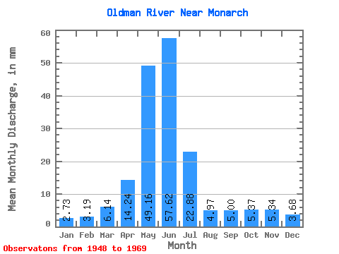
| Statistic | Jan | Feb | Mar | Apr | May | Jun | Jul | Aug | Sep | Oct | Nov | Dec | Annual |
|---|---|---|---|---|---|---|---|---|---|---|---|---|---|
| Mean | 2.50 | 2.94 | 5.62 | 13.04 | 45.00 | 52.75 | 20.94 | 4.55 | 4.58 | 4.92 | 4.89 | 3.37 | 166.07 |
| Standard Deviation | 0.99 | 1.15 | 2.61 | 7.68 | 15.76 | 30.57 | 13.00 | 3.25 | 7.68 | 5.42 | 2.52 | 1.55 | 63.01 |
| Min | 1.47 | 1.46 | 2.09 | 2.09 | 19.15 | 22.80 | 3.83 | 0.47 | 0.36 | 0.65 | 2.36 | 1.69 | 84.22 |
| Max | 6.18 | 5.44 | 10.83 | 31.23 | 82.63 | 152.37 | 48.25 | 15.11 | 35.61 | 25.03 | 12.79 | 7.81 | 337.69 |
| Coefficient of Variation | 0.40 | 0.39 | 0.46 | 0.59 | 0.35 | 0.58 | 0.62 | 0.71 | 1.68 | 1.10 | 0.52 | 0.46 | 0.38 |
 Return to R-Arctic Net Home Page