|
|
|||||||||||||||||
| Point ID: 9697 | Downloads | Plots | Site Data | Code: 05060500 |
|
|
|||||||||||||||||
| Download | |
|---|---|
| Site Descriptor Information | Site Time Series Data |
| Link to all available data | |
| View: | Time Series | All |
| Units: | m3/s |
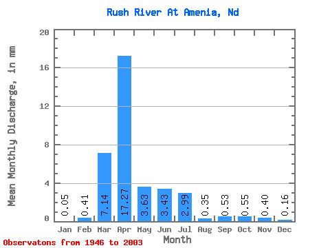
| Statistic | Jan | Feb | Mar | Apr | May | Jun | Jul | Aug | Sep | Oct | Nov | Dec | Annual |
|---|---|---|---|---|---|---|---|---|---|---|---|---|---|
| Mean | 0.06 | 0.41 | 7.14 | 17.27 | 3.63 | 3.43 | 2.99 | 0.35 | 0.53 | 0.55 | 0.40 | 0.16 | 37.23 |
| Standard Deviation | 0.15 | 2.56 | 10.56 | 24.93 | 4.64 | 5.86 | 6.53 | 1.05 | 1.98 | 1.82 | 0.85 | 0.46 | 37.36 |
| Min | 0.00 | 0.00 | 0.00 | 0.28 | 0.03 | 0.00 | 0.00 | 0.00 | 0.00 | 0.00 | 0.00 | 0.00 | 2.36 |
| Max | 0.72 | 19.36 | 50.46 | 129.63 | 20.53 | 30.16 | 42.40 | 5.62 | 11.57 | 12.80 | 5.39 | 3.15 | 188.37 |
| Coefficient of Variation | 2.55 | 6.22 | 1.48 | 1.44 | 1.28 | 1.71 | 2.18 | 3.00 | 3.72 | 3.30 | 2.16 | 2.85 | 1.00 |
 Return to R-Arctic Net Home Page