|
|
|||||||||||||||||
| Point ID: 9696 | Downloads | Plots | Site Data | Code: 05092000 |
|
|
|||||||||||||||||
| Download | |
|---|---|
| Site Descriptor Information | Site Time Series Data |
| Link to all available data | |
| View: | Time Series | All |
| Units: | m3/s |
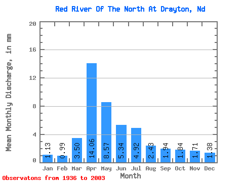
| Statistic | Jan | Feb | Mar | Apr | May | Jun | Jul | Aug | Sep | Oct | Nov | Dec | Annual |
|---|---|---|---|---|---|---|---|---|---|---|---|---|---|
| Mean | 1.01 | 0.89 | 3.12 | 12.52 | 7.63 | 4.76 | 4.38 | 2.16 | 1.73 | 1.64 | 1.53 | 1.23 | 43.81 |
| Standard Deviation | 0.56 | 0.48 | 3.59 | 9.74 | 8.60 | 3.76 | 4.37 | 2.55 | 1.66 | 1.15 | 1.45 | 0.82 | 26.48 |
| Min | 0.15 | 0.15 | 0.23 | 1.04 | 0.79 | 0.33 | 0.10 | 0.04 | 0.02 | 0.01 | 0.01 | 0.13 | 7.85 |
| Max | 2.25 | 1.99 | 18.45 | 44.55 | 49.55 | 19.07 | 23.76 | 18.15 | 9.89 | 4.37 | 9.64 | 3.51 | 114.41 |
| Coefficient of Variation | 0.56 | 0.54 | 1.15 | 0.78 | 1.13 | 0.79 | 1.00 | 1.18 | 0.96 | 0.70 | 0.95 | 0.67 | 0.60 |
 Return to R-Arctic Net Home Page