|
|
|||||||||||||||||
| Point ID: 9691 | Downloads | Plots | Site Data | Code: 05059000 |
|
|
|||||||||||||||||
| Download | |
|---|---|
| Site Descriptor Information | Site Time Series Data |
| Link to all available data | |
| View: | Time Series | All |
| Units: | m3/s |
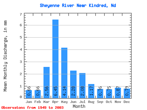
| Statistic | Jan | Feb | Mar | Apr | May | Jun | Jul | Aug | Sep | Oct | Nov | Dec | Annual |
|---|---|---|---|---|---|---|---|---|---|---|---|---|---|
| Mean | 0.29 | 0.29 | 1.11 | 2.79 | 1.79 | 0.98 | 0.90 | 0.50 | 0.33 | 0.32 | 0.38 | 0.34 | 10.08 |
| Standard Deviation | 0.19 | 0.21 | 1.13 | 2.77 | 2.28 | 0.98 | 1.05 | 1.01 | 0.39 | 0.34 | 0.36 | 0.28 | 7.64 |
| Min | 0.06 | 0.07 | 0.12 | 0.23 | 0.18 | 0.16 | 0.09 | 0.06 | 0.08 | 0.08 | 0.07 | 0.06 | 1.90 |
| Max | 0.81 | 0.96 | 4.18 | 12.74 | 10.16 | 6.24 | 4.88 | 7.42 | 1.70 | 2.30 | 1.90 | 1.33 | 30.27 |
| Coefficient of Variation | 0.66 | 0.71 | 1.02 | 1.00 | 1.28 | 1.00 | 1.17 | 2.01 | 1.17 | 1.05 | 0.96 | 0.83 | 0.76 |
 Return to R-Arctic Net Home Page