|
|
|||||||||||||||||
| Point ID: 9681 | Downloads | Plots | Site Data | Code: 05058700 |
|
|
|||||||||||||||||
| Download | |
|---|---|
| Site Descriptor Information | Site Time Series Data |
| Link to all available data | |
| View: | Time Series | All |
| Units: | m3/s |
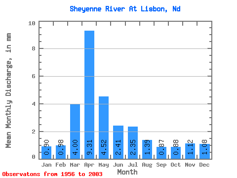
| Statistic | Jan | Feb | Mar | Apr | May | Jun | Jul | Aug | Sep | Oct | Nov | Dec | Annual |
|---|---|---|---|---|---|---|---|---|---|---|---|---|---|
| Mean | 0.27 | 0.30 | 1.22 | 2.83 | 1.38 | 0.73 | 0.71 | 0.42 | 0.27 | 0.27 | 0.34 | 0.33 | 9.14 |
| Standard Deviation | 0.19 | 0.26 | 1.33 | 3.15 | 1.83 | 0.69 | 0.97 | 1.03 | 0.40 | 0.39 | 0.35 | 0.29 | 7.46 |
| Min | 0.03 | 0.04 | 0.07 | 0.07 | 0.06 | 0.05 | 0.02 | 0.02 | 0.01 | 0.03 | 0.04 | 0.03 | 1.08 |
| Max | 0.78 | 1.34 | 5.45 | 14.47 | 8.56 | 3.35 | 5.09 | 6.95 | 1.94 | 2.56 | 1.66 | 1.40 | 30.45 |
| Coefficient of Variation | 0.71 | 0.85 | 1.10 | 1.11 | 1.33 | 0.94 | 1.36 | 2.44 | 1.51 | 1.45 | 1.03 | 0.89 | 0.82 |
 Return to R-Arctic Net Home Page