|
|
|||||||||||||||||
| Point ID: 9680 | Downloads | Plots | Site Data | Code: 05056400 |
|
|
|||||||||||||||||
| Download | |
|---|---|
| Site Descriptor Information | Site Time Series Data |
| Link to all available data | |
| View: | Time Series | All |
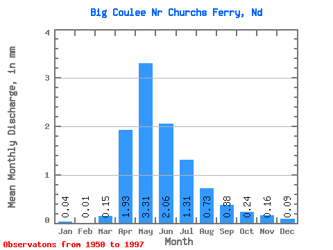
| Units: | m3/s |
| Statistic | Jan | Feb | Mar | Apr | May | Jun | Jul | Aug | Sep | Oct | Nov | Dec | Annual |
|---|---|---|---|---|---|---|---|---|---|---|---|---|---|
| Mean | 0.03 | 0.01 | 0.11 | 1.40 | 2.40 | 1.49 | 0.95 | 0.53 | 0.28 | 0.17 | 0.12 | 0.07 | 6.49 |
| Standard Deviation | 0.09 | 0.04 | 0.27 | 2.42 | 4.37 | 2.71 | 1.59 | 0.98 | 0.68 | 0.47 | 0.30 | 0.19 | 9.29 |
| Min | 0.00 | 0.00 | 0.00 | 0.00 | 0.00 | 0.00 | 0.00 | 0.00 | 0.00 | 0.00 | 0.00 | 0.00 | 0.00 |
| Max | 0.46 | 0.19 | 1.53 | 12.98 | 23.32 | 11.62 | 6.92 | 4.00 | 3.75 | 2.96 | 1.91 | 1.11 | 37.85 |
| Coefficient of Variation | 3.39 | 3.21 | 2.45 | 1.73 | 1.82 | 1.81 | 1.68 | 1.85 | 2.43 | 2.69 | 2.56 | 2.87 | 1.43 |
 Return to R-Arctic Net Home Page