|
|
|||||||||||||||||
| Point ID: 9664 | Downloads | Plots | Site Data | Code: 05060000 |
|
|
|||||||||||||||||
| Download | |
|---|---|
| Site Descriptor Information | Site Time Series Data |
| Link to all available data | |
| View: | Time Series | All |
| Units: | m3/s |
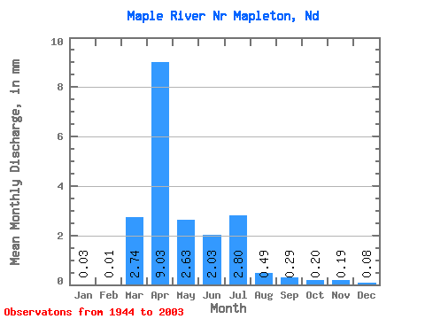
| Statistic | Jan | Feb | Mar | Apr | May | Jun | Jul | Aug | Sep | Oct | Nov | Dec | Annual |
|---|---|---|---|---|---|---|---|---|---|---|---|---|---|
| Mean | 0.02 | 0.01 | 2.61 | 8.58 | 2.50 | 1.93 | 2.67 | 0.46 | 0.28 | 0.19 | 0.18 | 0.08 | 15.14 |
| Standard Deviation | 0.03 | 0.02 | 5.02 | 9.66 | 3.01 | 2.94 | 8.15 | 0.92 | 0.33 | 0.28 | 0.16 | 0.07 | 13.51 |
| Min | 0.00 | 0.00 | 0.00 | 0.27 | 0.13 | 0.03 | 0.00 | 0.00 | 0.00 | 0.00 | 0.00 | 0.00 | 1.97 |
| Max | 0.09 | 0.09 | 21.00 | 33.39 | 12.51 | 14.00 | 47.95 | 5.39 | 1.28 | 1.03 | 0.71 | 0.25 | 46.85 |
| Coefficient of Variation | 1.08 | 1.73 | 1.93 | 1.13 | 1.21 | 1.52 | 3.06 | 1.99 | 1.21 | 1.50 | 0.91 | 0.87 | 0.89 |
 Return to R-Arctic Net Home Page