|
|
|||||||||||||||||
| Point ID: 9661 | Downloads | Plots | Site Data | Code: 05098700 |
|
|
|||||||||||||||||
| Download | |
|---|---|
| Site Descriptor Information | Site Time Series Data |
| Link to all available data | |
| View: | Time Series | All |
| Units: | m3/s |
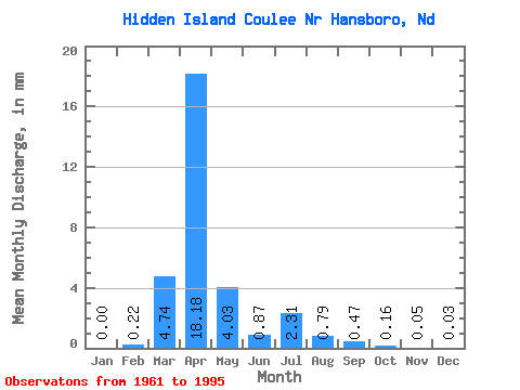
| Statistic | Jan | Feb | Mar | Apr | May | Jun | Jul | Aug | Sep | Oct | Nov | Dec | Annual |
|---|---|---|---|---|---|---|---|---|---|---|---|---|---|
| Mean | 0.00 | 0.23 | 4.74 | 18.17 | 4.03 | 0.86 | 2.31 | 0.80 | 0.47 | 0.16 | 0.04 | 0.03 | 29.22 |
| Standard Deviation | 0.00 | 1.37 | 10.93 | 24.76 | 7.90 | 1.73 | 7.99 | 2.65 | 2.15 | 0.62 | 0.15 | 0.14 | 29.55 |
| Min | 0.00 | 0.00 | 0.00 | 0.00 | 0.00 | 0.00 | 0.00 | 0.00 | 0.00 | 0.00 | 0.00 | 0.00 | 0.02 |
| Max | 0.01 | 7.97 | 59.74 | 87.24 | 33.83 | 6.97 | 44.20 | 13.18 | 12.49 | 3.56 | 0.78 | 0.79 | 126.26 |
| Coefficient of Variation | 4.16 | 5.83 | 2.31 | 1.36 | 1.96 | 2.01 | 3.46 | 3.32 | 4.62 | 3.95 | 3.34 | 5.42 | 1.01 |
 Return to R-Arctic Net Home Page