|
|
|||||||||||||||||
| Point ID: 9659 | Downloads | Plots | Site Data | Code: 05123900 |
|
|
|||||||||||||||||
| Download | |
|---|---|
| Site Descriptor Information | Site Time Series Data |
| Link to all available data | |
| View: | Time Series | All |
| Units: | m3/s |
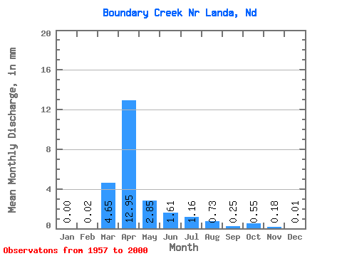
| Statistic | Jan | Feb | Mar | Apr | May | Jun | Jul | Aug | Sep | Oct | Nov | Dec | Annual |
|---|---|---|---|---|---|---|---|---|---|---|---|---|---|
| Mean | 0.00 | 0.01 | 3.43 | 9.57 | 2.10 | 1.19 | 0.86 | 0.54 | 0.18 | 0.41 | 0.13 | 0.01 | 19.01 |
| Standard Deviation | 0.00 | 0.05 | 6.19 | 16.49 | 5.31 | 3.15 | 1.97 | 1.40 | 0.51 | 1.25 | 0.38 | 0.03 | 22.16 |
| Min | 0.00 | 0.00 | 0.00 | 0.00 | 0.00 | 0.00 | 0.00 | 0.00 | 0.00 | 0.00 | 0.00 | 0.00 | 0.06 |
| Max | 0.02 | 0.26 | 21.26 | 66.23 | 30.57 | 16.60 | 10.32 | 6.65 | 2.73 | 5.89 | 1.38 | 0.16 | 78.28 |
| Coefficient of Variation | 4.90 | 4.37 | 1.80 | 1.72 | 2.52 | 2.65 | 2.30 | 2.58 | 2.75 | 3.07 | 2.95 | 4.22 | 1.17 |
 Return to R-Arctic Net Home Page