|
|
|||||||||||||||||
| Point ID: 9642 | Downloads | Plots | Site Data | Code: 05100500 |
|
|
|||||||||||||||||
| Download | |
|---|---|
| Site Descriptor Information | Site Time Series Data |
| Link to all available data | |
| View: | Time Series | All |
| Units: | m3/s |
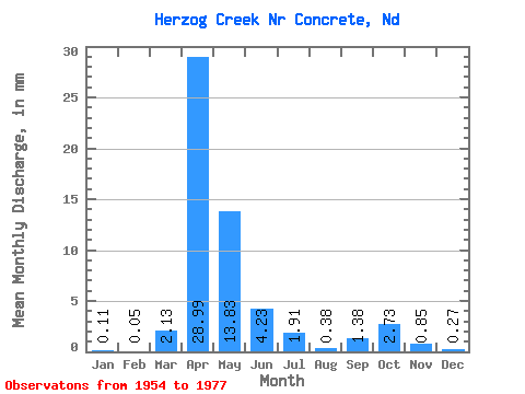
| Statistic | Jan | Feb | Mar | Apr | May | Jun | Jul | Aug | Sep | Oct | Nov | Dec | Annual |
|---|---|---|---|---|---|---|---|---|---|---|---|---|---|
| Mean | 0.09 | 0.04 | 2.14 | 29.00 | 13.84 | 4.24 | 1.91 | 0.37 | 1.39 | 2.72 | 0.83 | 0.25 | 59.42 |
| Standard Deviation | 0.33 | 0.11 | 4.39 | 24.87 | 17.63 | 4.64 | 2.54 | 0.80 | 2.68 | 4.08 | 1.04 | 0.58 | 40.52 |
| Min | 0.00 | 0.00 | 0.00 | 0.09 | 0.00 | 0.00 | 0.00 | 0.00 | 0.00 | 0.00 | 0.00 | 0.00 | 0.33 |
| Max | 1.61 | 0.48 | 18.01 | 72.77 | 58.41 | 15.32 | 8.47 | 3.51 | 10.08 | 13.61 | 3.30 | 2.78 | 133.38 |
| Coefficient of Variation | 3.66 | 2.96 | 2.05 | 0.86 | 1.27 | 1.09 | 1.33 | 2.15 | 1.93 | 1.50 | 1.25 | 2.34 | 0.68 |
 Return to R-Arctic Net Home Page