|
|
|||||||||||||||||
| Point ID: 9639 | Downloads | Plots | Site Data | Code: 05113500 |
|
|
|||||||||||||||||
| Download | |
|---|---|
| Site Descriptor Information | Site Time Series Data |
| Link to all available data | |
| View: | Time Series | All |
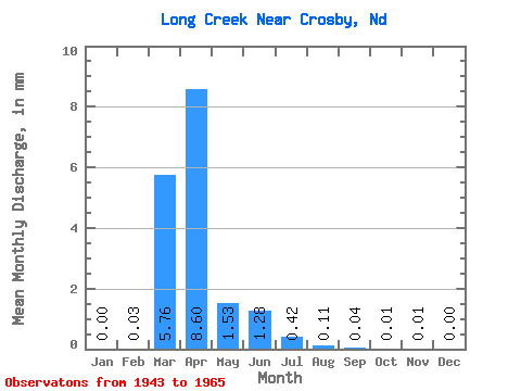
| Units: | m3/s |
| Statistic | Jan | Feb | Mar | Apr | May | Jun | Jul | Aug | Sep | Oct | Nov | Dec | Annual |
|---|---|---|---|---|---|---|---|---|---|---|---|---|---|
| Mean | 0.00 | 0.01 | 2.16 | 3.22 | 0.57 | 0.48 | 0.16 | 0.04 | 0.02 | 0.00 | 0.00 | 0.00 | 4.02 |
| Standard Deviation | 0.00 | 0.05 | 8.02 | 5.36 | 1.12 | 1.01 | 0.41 | 0.11 | 0.04 | 0.02 | 0.01 | 0.01 | 4.41 |
| Min | 0.00 | 0.00 | 0.00 | 0.00 | 0.00 | 0.00 | 0.00 | 0.00 | 0.00 | 0.00 | 0.00 | 0.00 | 0.00 |
| Max | 0.01 | 0.24 | 37.87 | 21.70 | 4.29 | 4.07 | 1.83 | 0.51 | 0.14 | 0.07 | 0.04 | 0.02 | 18.10 |
| Coefficient of Variation | 3.16 | 4.57 | 3.72 | 1.66 | 1.96 | 2.11 | 2.62 | 2.70 | 2.37 | 4.39 | 4.07 | 3.09 | 1.10 |
 Return to R-Arctic Net Home Page