|
|
|||||||||||||||||
| Point ID: 9627 | Downloads | Plots | Site Data | Code: 05055500 |
|
|
|||||||||||||||||
| Download | |
|---|---|
| Site Descriptor Information | Site Time Series Data |
| Link to all available data | |
| View: | Time Series | All |
| Units: | m3/s |
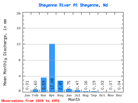
| Statistic | Jan | Feb | Mar | Apr | May | Jun | Jul | Aug | Sep | Oct | Nov | Dec | Annual |
|---|---|---|---|---|---|---|---|---|---|---|---|---|---|
| Mean | 0.00 | 0.22 | 1.32 | 4.46 | 1.05 | 0.28 | 0.17 | 0.06 | 0.07 | 0.01 | 0.03 | 0.01 | 8.00 |
| Standard Deviation | 0.01 | 0.81 | 1.64 | 6.21 | 2.35 | 0.31 | 0.29 | 0.10 | 0.17 | 0.03 | 0.04 | 0.02 | 8.48 |
| Min | 0.00 | 0.00 | 0.00 | 0.13 | 0.04 | 0.01 | 0.00 | 0.00 | 0.00 | 0.00 | 0.00 | 0.00 | 0.50 |
| Max | 0.02 | 3.24 | 4.19 | 20.18 | 9.96 | 0.96 | 1.20 | 0.39 | 0.63 | 0.10 | 0.16 | 0.09 | 31.79 |
| Coefficient of Variation | 1.75 | 3.64 | 1.24 | 1.40 | 2.23 | 1.11 | 1.66 | 1.78 | 2.43 | 2.21 | 1.71 | 1.65 | 1.06 |
 Return to R-Arctic Net Home Page