|
|
|||||||||||||||||
| Point ID: 9625 | Downloads | Plots | Site Data | Code: 05068000 |
|
|
|||||||||||||||||
| Download | |
|---|---|
| Site Descriptor Information | Site Time Series Data |
| Link to all available data | |
| View: | Time Series | All |
| Units: | m3/s |
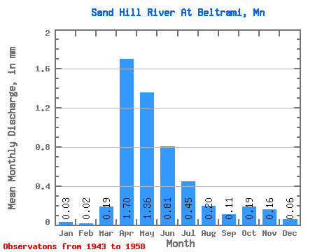
| Statistic | Jan | Feb | Mar | Apr | May | Jun | Jul | Aug | Sep | Oct | Nov | Dec | Annual |
|---|---|---|---|---|---|---|---|---|---|---|---|---|---|
| Mean | 0.03 | 0.02 | 0.18 | 1.70 | 1.36 | 0.81 | 0.45 | 0.20 | 0.10 | 0.19 | 0.17 | 0.06 | 5.70 |
| Standard Deviation | 0.03 | 0.03 | 0.33 | 1.13 | 1.82 | 0.67 | 0.51 | 0.18 | 0.09 | 0.15 | 0.11 | 0.04 | 3.38 |
| Min | 0.00 | 0.00 | 0.00 | 0.01 | 0.01 | 0.07 | 0.02 | 0.00 | 0.00 | 0.01 | 0.04 | 0.00 | 0.75 |
| Max | 0.08 | 0.07 | 1.17 | 3.77 | 7.61 | 2.66 | 2.05 | 0.72 | 0.30 | 0.48 | 0.48 | 0.13 | 13.82 |
| Coefficient of Variation | 1.11 | 1.45 | 1.78 | 0.67 | 1.34 | 0.82 | 1.13 | 0.88 | 0.81 | 0.80 | 0.67 | 0.73 | 0.59 |
 Return to R-Arctic Net Home Page