|
|
|||||||||||||||||
| Point ID: 9624 | Downloads | Plots | Site Data | Code: 05051300 |
|
|
|||||||||||||||||
| Download | |
|---|---|
| Site Descriptor Information | Site Time Series Data |
| Link to all available data | |
| View: | Time Series | All |
| Units: | m3/s |
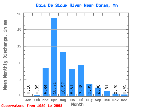
| Statistic | Jan | Feb | Mar | Apr | May | Jun | Jul | Aug | Sep | Oct | Nov | Dec | Annual |
|---|---|---|---|---|---|---|---|---|---|---|---|---|---|
| Mean | 0.10 | 0.40 | 6.84 | 18.70 | 10.57 | 6.61 | 7.48 | 2.99 | 2.08 | 1.31 | 0.70 | 0.49 | 60.91 |
| Standard Deviation | 0.18 | 0.73 | 6.90 | 27.32 | 10.91 | 5.77 | 7.52 | 6.11 | 5.13 | 2.64 | 1.84 | 1.01 | 49.68 |
| Min | 0.00 | 0.00 | 0.40 | 0.19 | 0.18 | 0.19 | 0.07 | 0.00 | 0.00 | 0.00 | 0.03 | 0.01 | 1.07 |
| Max | 0.68 | 2.20 | 27.37 | 89.47 | 29.48 | 21.59 | 23.00 | 23.15 | 18.76 | 9.22 | 7.01 | 3.45 | 146.96 |
| Coefficient of Variation | 1.74 | 1.86 | 1.01 | 1.46 | 1.03 | 0.87 | 1.01 | 2.04 | 2.46 | 2.02 | 2.64 | 2.07 | 0.82 |
 Return to R-Arctic Net Home Page